
Each spring, rivers and streams throughout the county rise as the snow in the mountains begins to melt away. In some years, this rise in the water happens gradually over time; in other years there can be drastic “spikes” that happen suddenly due to certain conditions. Rivers, streams and their tributaries fluctuate greatly in the amount of water that they carry from year to year and season to season. Many factors contribute to this annual spring runoff or “high water” and the timing of this phenomena is affected by many variables such as: how much total snow was received, how much snow-water equivalent was retained in the snow, spring precipitation amounts, wind velocities, increasing daytime temperatures, overnight low temperatures, dam regulation and water diversions, to name a few.
This item is available in full to subscribers.
To continue reading, you will need to either log in to your subscriber account, below, or purchase a new subscription.
Please log in to continue |
Each spring, rivers and streams throughout the county rise as the snow in the mountains begins to melt away. In some years, this rise in the water happens gradually over time; in other years there can be drastic “spikes” that happen suddenly due to certain conditions. Rivers, streams and their tributaries fluctuate greatly in the amount of water that they carry from year to year and season to season. Many factors contribute to this annual spring runoff or “high water” and the timing of this phenomena is affected by many variables such as: how much total snow was received, how much snow-water equivalent was retained in the snow, spring precipitation amounts, wind velocities, increasing daytime temperatures, overnight low temperatures, dam regulation and water diversions, to name a few.
How is the flow of water measured?
Streamflow, or discharge, is generally reported as “CFS.” CFS, or cubic feet per second, is a measure of the volume of water passing any given point in a river in 1 second. CFS is relative to each stream and as one could imagine 8,000 CFS on the Green River would mean something vastly different than 8,000 CFS on the Little Sandy or New Fork. Height gages are another way that flow is measured and are usually reported in feet. Gages measure the height of water above a specific reference point and are not related to the depth of the reach.
Why is it important to know flow?
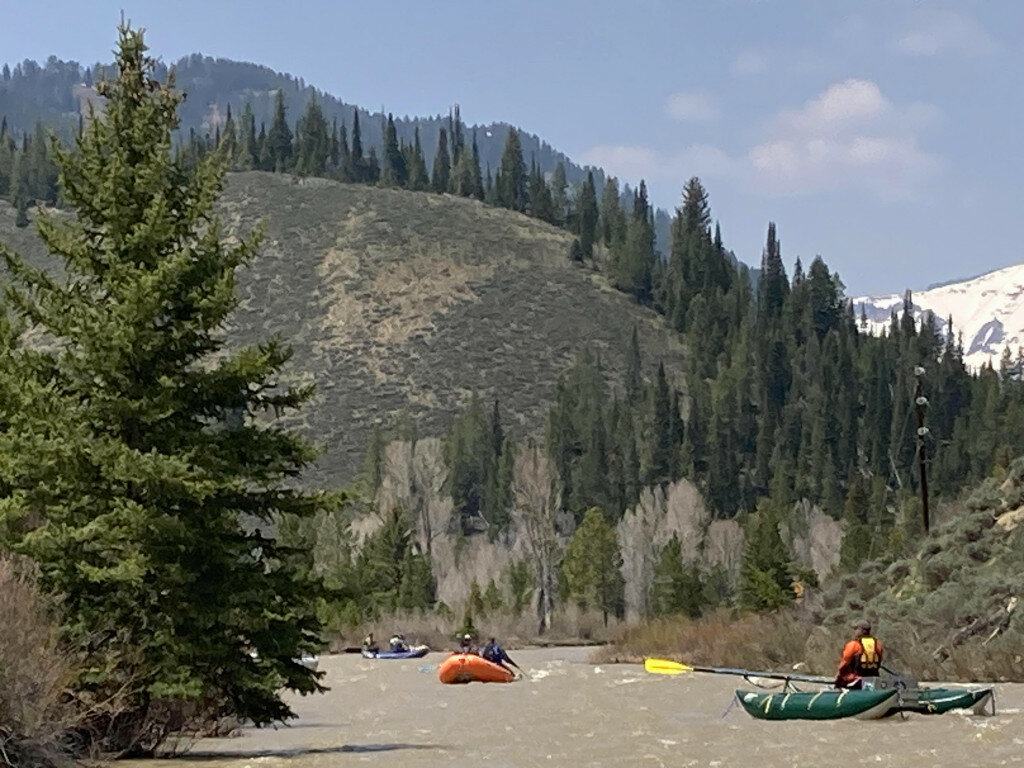
The rate of streamflow can help guide personal decision making on when to work or recreate in or around a particular stretch of water. Knowing the streamflow and implications of certain levels could help one to determine whether to cross a stream, put a boat on the water or just put off that adventure for another few weeks to let the waters come down. Spring boating can have its perks such as low crowds, no biting insects and watching amazing bird migrations along the river corridors; however, drawbacks can include very cold water, swift currents, low bridges and unpredictable hazards.
The amount of CFS can also help anglers determine where fish are distributed in the channels. For example, in low flows, fish may be limited to deeper pools, while at high flows they may be in hiding in eddies and along banks to escape harsh and fast currents. Knowing the flow might help increase angling success. For river stretches with low bridges such as the Hoback, knowing the level at which bridges may become impassable would be crucial for safety. When you are familiar with a stretch of river, you may know what channels become navigable at certain flows and what obstacles may become present or possible.
Of course, debris in the water is a hazard that increases with high flows when objects such as logs, shrubs and woody debris become dislodged and are moving down the river. In braided and meandering systems, channels may open up or become blocked overnight with rapid fluctuations in CFS.
How do you know how “high” the water is in our local rivers?
One of the best resources for streamflow data is the USGS National Water Information System (USGS, 2023). This website allows you to look through and compare years of streamflow data with a few clicks of the mouse. You can refine your search to Wyoming and further into specific watersheds or drainages. There are approximately 90 years’ worth of data on the Green River at Warren Bridge and 67 years of data on the New Fork at Big Piney. There are four stations in Sublette County that report continuous streamflow data. Those stations include the Green River at Warren Bridge, Pine Creek above Fremont Lake, New Fork River near Big Piney and Big Sandy Reservoir near Farson.
Other resources include the Wyoming State Engineers office with links to statewide flow data, Wyoming Snow Data and Wyoming Weather Data (WY State Engineer’s Office 2023) and U.S. Department of Agriculture Natural Resources Conservation Service Water Supply Forecasting tools and website (NRCS 2023) where you can even subscribe to receive reports to your inbox.
If you have any further questions, please contact the Sublette County Conservation District at 307-367-2364.
References: https://waterdata.usgs.gov , https://seoflow.wyo.gov , https://www.nrcs.usda.gov/resources/data-and-reports/water-supply-forecasting.


