

The recent warm weather has area residents out soaking up the sunshine as the days get longer this spring. Despite the warmer trend experienced in the past few weeks in and around Pinedale, residents are not out of the woods just yet.
This item is available in full to subscribers.
To continue reading, you will need to either log in to your subscriber account, or purchase a new subscription.
If you are a current print subscriber, you can set up a free website account and connect your subscription to it by clicking here.
If you are a digital subscriber with an active, online-only subscription then you already have an account here. Just reset your password if you've not yet logged in to your account on this new site.
Otherwise, click here to view your options for subscribing.
Please log in to continue |
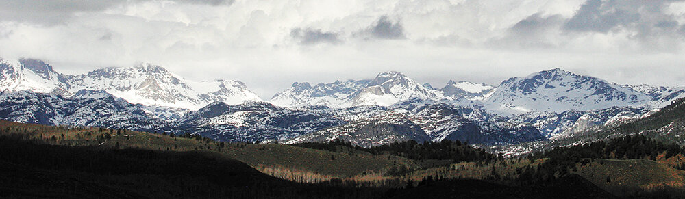
PINEDALE – The recent warm weather has area residents out soaking up the sunshine as the days get longer this spring. Despite the warmer trend experienced in the past few weeks in and around Pinedale, residents are not out of the woods just yet.
This past winter saw the highest snowfall ever recorded in Pinedale, as 156 inches of the white stuff were recorded from October of last year through April. The previous record of 137.5 inches, set back in the winter of 1971-72, was surpassed back in February of this year.
According to National Weather Service meteorologist Chris Jones, a cold front pushing through the region on Saturday is expected to drop temperatures down to seasonal levels, and could even bring one to two inches of snow in lower elevations.
“It may be cold enough to add an inch or two to the record snowpack,” Jones said. “Even in the recent past, snow in May is not unheard of.”
Twenty inches fell in May of 2014, while 10 inches fell in May of 2005.
Since early March, only 15 percent of the snowpack up in the Upper Green River Basin has melted out, and Jones says a number of factors will dictate how future melting and subsequent flooding will come into play. Currently, the Upper Green has a snowpack sitting at 185 percent of normal.
“There is still a good amount of snow up at Gunsight Pass and Elkhart Park,” Jones said. “Those areas still have 18 to 23 inches of water in the snowpack; that is significantly above normal.”
At lower elevations, such as Kendall Ranger Station in the Upper Green, 7.8 inches of snow-water equivalent (SWE) remain, while up at New Fork Lake, the snow currently holds 5.9 inches of water.
Warmer weather will bring rising stream and river levels, but it is currently unknown how the snow will come off. Jones says three days or more with temperatures in the upper 70s could bring some snow off the current pack, but it is too hard to tell due to other factors that impact the melt. Other causes for snowmelt include a full sunshine day, nighttime temperatures and wind.
“It doesn’t take a certain temperature or number of days because there are other factors,” he said. “Rain is also efficient in melting snow.”
Models show areas of Sublette County, especially at the confluence of the Green River and New Fork River and on the lower Green River at the southern end of the county showing high potential for snowmelt flooding, while other areas northeast of Pinedale and west of Big Piney showing moderate to high flood potential.
“There is a very good chance to see flooding,” Jones said. “The question is, when do we see an active snowmelt?”
With more and more avid outdoor lovers taking advantage of warm weather, it is important for folks to be cautious in the spring months around smaller tributaries.
If out hiking and camping, a stream that was easy to cross one day may become a turbulent force the next day with little or no warning.
“Creeks and waterways can start running high quickly,” Jones said. “People need to be careful.”
According to Sublette County Emergency Management Coordinator Jim Mitchell, flows are already running high in area waterways and this is only the beginning.
On Monday at 6:45 a.m., water from the Green River at Warren Bridge was at 1,760 cubic feet per second (cfs) and by Wednesday morning of this week, the water rose to a level of 2,610 cfs. In light of that, Mitchell suggests that residents not waste any time preparing for potential flooding if they live near a waterway.
One thing Mitchell urges those who live in an area that could see impact from high water is to go ahead and sign up for flood insurance, as the policy has to be in place 30 days prior to an incident taking place. If you live in a Federal Emergency Management Agency (FEMA) designated flood zone and you have a mortgage, it is required to have flood insurance. However, you don’t have to be in a flood plain to sign up for flood insurance. With so much snow this past winter, basements in Pinedale flooded, although the town is not in a flood plain. Homeowners insurance will not cover such flooding, according to Farm Bureau Insurance.
Pinedale retailers have been asked to purchase sandbags to have on standby for locals, since they are the first line of defense.
“Private property is the responsibility of the landowner,” Mitchell said. “I told retailers they should make sandbags available for purchase to protect critical infrastructure.”
Sandbags can be useful if protecting a small swath of area, however, covering a large area takes a lot of sandbags. He suggests people in select situations to build a berm and grow grass on it to protect from rising water.
Overall, he says the water is coming and to be ready for it when it arrives.
“Be prepared,” Mitchell urged. “Know how to evacuate yourself and park on the other side of the water. The time is now to take care of property.”


