

A historic winter season of snowfall, coupled with recent warm springtime temperatures, has caused area streams and rivers to run high and breach their banks.
This item is available in full to subscribers.
To continue reading, you will need to either log in to your subscriber account, or purchase a new subscription.
If you are a current print subscriber, you can set up a free website account and connect your subscription to it by clicking here.
If you are a digital subscriber with an active, online-only subscription then you already have an account here. Just reset your password if you've not yet logged in to your account on this new site.
Otherwise, click here to view your options for subscribing.
Please log in to continue |
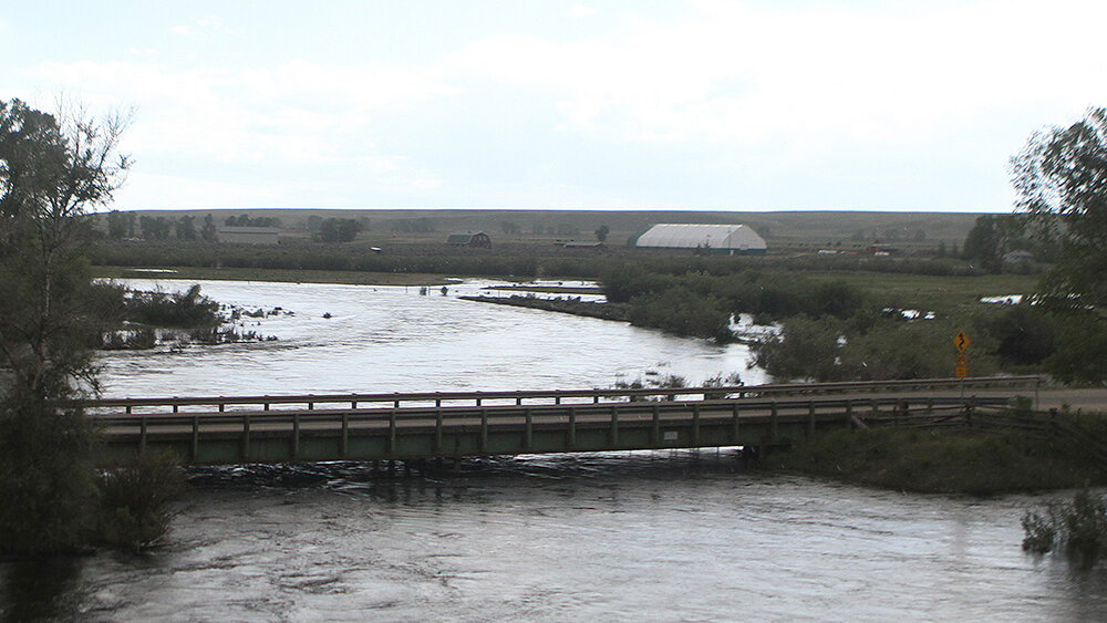
SUBLETTE COUNTY – A historic winter season of snowfall, coupled with recent warm springtime temperatures, has caused area streams and rivers to run high and breach their banks. In addition, many roadways in the Bridger-Teton National Forest have succumbed to washouts and flooding.
There are several low-lying areas surrounding the county waterways that have flooded with feet of water as the early snowpack runoff flushes out of Sublette County. A cold snap this week – including snowfall Monday night – helped ease stream flows, at least temporarily.
The Green River near LaBarge saw a peak of 18,000 cubic feet per second (cfs) over the weekend between Saturday evening and Sunday morning. The reading exceeds the peak of high water observed back on July 3, 2011, which was another big snow year for the region. The National Weather Service predicted a crest of 18,300 cfs (10.3 feet), which would have been the second largest flow since 1947. The river reached a depth of 10.23 feet just after 10 a.m. on Sunday, putting it into the moderate flood stage range. The record for high water at this site is 10.5 feet.
According to Jim Mitchell of Sublette County Emergency Management, cooler temperatures and area snowfall early this week will drop stream flows temporarily, before another warming trend later in the week will cause rivers to crest once again.
Mitchell further advises that people near any river need to be prepared to move without much notice. He suggests having a “fly away” kit at the ready to grab if flooding causes evacuation measures. At this time, Mitchell suggests staying away from water, and for hikers, river crossings are ill advised.


