

Some 550 miles of the Continental Divide Trail — the iconic thru-hiking route that rides the spine of the Rocky Mountains from Canada to Mexico — unfurl across Wyoming. The trail passes through Yellowstone National Park, skips over wind-scoured ridges of the Wind River Range and traverses sagebrush seas in the southern reaches of the state.
This item is available in full to subscribers.
To continue reading, you will need to either log in to your subscriber account, or purchase a new subscription.
If you are a current print subscriber, you can set up a free website account and connect your subscription to it by clicking here.
If you are a digital subscriber with an active, online-only subscription then you already have an account here. Just reset your password if you've not yet logged in to your account on this new site.
Otherwise, click here to view your options for subscribing.
Please log in to continue |
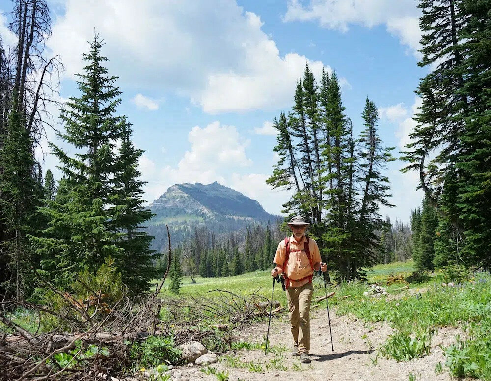
Some 550 miles of the Continental Divide Trail — the iconic thru-hiking route that rides the spine of the Rocky Mountains from Canada to Mexico — unfurl across Wyoming. The trail passes through Yellowstone National Park, skips over wind-scoured ridges of the Wind River Range and traverses sagebrush seas in the southern reaches of the state.
But when Chris Sellars thru-hiked the CDT in 2013 with his wife, he said, there was a section in Wyoming that was a bit forgettable.
“There was this kind of like throwaway section, which was from the Thoroughfare to the Winds,” he said. As a resident of Wyoming, Sellars said, he knew that area contained staggering beauty. But the link-up, which was mostly on old dirt roads, didn’t do much to capitalize on it.
That has all changed, thanks to a multi-year reroute project that’s on track to finish this summer. The project, helmed by the Shoshone National Forest and Wyoming Pathways, reroutes the CDT from Bear Cub Pass up and over the rocky notch of Sublette Pass, elevation 10,537 feet, then westward along the base of the Breccia Cliffs to Togwotee Pass.
What was once a road slog has been replaced by more than eight miles of wending singletrack with big alpine views. The grades are low, the trail has been built to withstand erosion and it’s designed for multi-use.
Sellars, who now serves as the Shoshone National Forest south zone trails coordinator, ended up playing a major role in the project. He sees it as something that can benefit a user group much larger than thru-hikers.
“I kind of was drawn to the project because of my own personal thru-hiking experience,” Sellars said. “But it’s become for me a lot more than just a couple hundred people a year that might be on a thru-hike. I’m hoping that it’ll see thousands of people a year that are looking for a nice spot to go on a day hike,” along with mountain bikers, equestrians, section hikers and more.
“For Wyoming to have such an iconic trail and, and have it be … such a bad experience was, you know, disappointing,” Wyoming Pathways Executive Director Tim Young says of the previous route. “It wasn’t a nice section.”
Young is standing in a highway pullout near Togwotee Pass on a recent July morning, geared up with trekking poles and bear spray. For the next several hours, he leads a hike on the new section of the CDT. Still soft in spots with recently upturned earth, the path skirts meadows festooned with bluebells, lupine and sticky geranium. It twists and turns, offers eye-popping views as it approaches the Breccia Cliffs and while it gains elevation, hiking on it never feels strenuous.
That is a function of a new school of thought behind trail design, Young says. Many historic trails were created by horse-packers or hikers who were aiming to get from point A to B as fast as possible, he says. But steep trails are prone to erosion, which makes them degrade quickly.
These days, he says, good trails are designed to minimize erosion. They are low-angle and sloped so that water can slough off. They are wide enough for their users. And that way, they don’t require constant maintenance.
“Be the water.” That’s the mantra trail builder Ron Murray follows as he designs paths, he says. Murray and his crew are working in dense woods a couple miles into the hike, breaking ground with a small excavator and hand tools as they finish a tricky section in some rocks.
“We’re hemmed in by certain things,” Murray says. “Grade being one of them, and the location we need to get to being the other. But I think the solutions will be elegant and ride well.”
The crew has endeavored to make this trail between 3-to-8-percent grade, even as it climbs up and over Sublette Pass. This requires some creativity, Young says, but the result is an enormous improvement over what previously existed.
“Well, the old route you didn’t walk along beautiful cliffs and pristine wild flowers,” he says. “It was more like an old road with timber cuts along the side and sort of down below where you didn’t have views.”
From Sublette Pass, the land tumbles from the blocky Breccia Cliffs down alpine slopes toward rugged woods. Brooks Lake nestles beneath ridges to the east. Young’s July excursion ends here, but the trail continues, meandering gently as it heads toward Bear Cub Pass and the hundreds of miles of CDT trail that remain.
Congress established the 3,100-mile Continental Divide National Scenic Trail in 1978. Today, it joins the Pacific Crest Trail and Appalachian Trail in what’s known as the Triple Crown of thru-hiking.
Of the three, the CDT requires the most route-finding, said Sellars, who has hiked all of them.
“So basically, you just need to stay as close to the Divide as you could as you try to go from Canada or Mexico, or Mexico to Canada,” Sellars said. “And (route establishers) wanted it to be that way. And they wanted it to be really rough and challenging and hard to navigate and all of that.”
The idea was great, Sellars said. But the reality has created challenges for trail managers to maintain the route and in some cases, hikers to find their way.
In the last decade, he said, the CDT interagency program manager has identified a goal to re-examine portions of the trail for better signage and improvements.
“One of their main goals or their main initiatives was like, we need to get this marked better,” Sellars said. “And we need to identify an actual route. And that’ll help us to get funding and be able to actually work on the trail and direct volunteers to work on the trail.”
That was part of the impetus behind the Wyoming project. The Lava Mountain Fire, which burned thousands of acres north of Dubois in 2016, also contributed, Sellars said, by damaging an area of the route that had already been identified as not ideal.
Finally, a timber sale created a conflict between commercial use and hiking on some of the roads, he said.
“And so between the timber sale, the fire and the push to take trails off roads and make them better marked and better maintained … all that kind of came to a head,” Sellars said. When he started as trails coordinator in 2017, he said, one of his first tasks was to reroute the section.
The Forest Service teamed up with Wyoming Pathways, which it had worked with successfully on a trail near Lander, for the reroute. The Forest Service funded the majority of the project through earmarked federal funds it applied for, with Wyoming Pathways donating what Young estimates is 10-to-15-percent of the cost.
Sellars, Young and others pored over maps and walked over a lot of the landscape. Once they flagged a route, they brought in small crews to build trail with mini-excavators and other tools.
The new route has already been designated the official CDT by land managers and system maps, Young said.
Based on permits, shuttle reservations and other factors, the Continental Divide Trail Coalition expects about 400 thru-hikers will undertake the CDT this season, Communications Coordinator Allie Ghaman said.
That’s up from 80 in 2014, and 220 in 2017.
Projects like this, Ghaman said, give a boost to the system.
“It’s definitely our goal to move as much trail as possible onto singletrack that emphasizes non-motorized usage,” she said. “So, very thrilled to have seen this project happen even though we were not directly commissioning it.”
Thru-hikers, Ghaman noted, are just one part of the community her organization encourages to experience the CDT.
Sellars envisions the new trail will become a destination for Wyoming residents and out-of-staters for many different activities.
“Whether it’s horses, mountain bikes, or hikers, trail runners,” he said, he hopes it gets a lot of use. It’s hard to beat as a day hike, he added.
Young echoed that. There aren’t many spots in Wyoming that offer such easy access to a high-elevation alpine trail, he said.
“This is going to offer (a) real high-quality experience,” he said.


